Sturgis 2009, Days 7, 8 & 9: Let’s wrap it up quickly, shall we?
by Corn Dog on August 18, 2009
in Sturgis 2009
 As a reward for your having suffered through the unreasonably long Day Six ride report, I’ve decided to keep things short and sweet when reporting on the rest of the trip. So here’s the wrap-up:
Day 7 – Kristin took off for home in the wee hours of the morning, and rode safely through to Des Moines by herself, trouble-free. The boys took off mid-morning to attempt a repeat of our aborted canyon ride from the day before. I stayed at the motel and took our soaked clothes to the laundromat to tumble around in the dryer, and Shirley hung around with me by doing a load of wash. We hog-tied a small child who climbed onto her bike uninvited. The boys returned safely, having found Spearfish Canyon right where it was supposed to be, just around the bend from where I’d stopped in Lead by the school.
Day 8 – Rode from Belle Fourche to Mitchell in really strong cross-winds. It sucked, but we made up for it by having a nice steak dinner at Chef Louie in Mitchell that evening.
Day 9 – Rode in fog from Mitchell to Sioux Falls, then rode in between two bands of rain all the way down I-29 and never got wet. Comment from Chuck: “Janet is the luckiest broad I know!” A mean-looking thunderstorm chased us eastward all the way across Iowa; we arrived home around 5 p.m., and at 5:30 the skies opened up. Luckiest broad indeed!
With that, Sturgis 2009 is one for the history books. I’ve been gathering some stray bits-n-pieces that I’ll share in a future post (or posts), and all our photos have been uploaded to two albums on Webshots.
In all I rode 2,021 miles; it rained every day – usually at about the same time – but we only got caught in it once; I can safely say I bonded with the new bike, but I can’t say that its nickname has come to me yet. Time for the next adventure!
Sturgis 2009, Day Six: The deer are mocking us. Oh, and it’s raining.
by Corn Dog on August 17, 2009
in Sturgis 2009
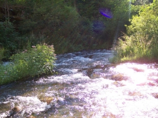
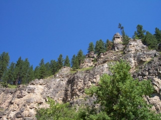 The other ride from our previous Sturgis trip that I wanted to be sure to repeat was the run through Spearfish Canyon. This road isn’t especially challenging, but it is stunningly beautiful and does have some nice sweeping curves that reveal rocky bluffs, babbling streams, and frequent opportunities to zip into a turn-out to take photos.
There’s also another canyon, named Vanocker, that we hadn’t visited in 2006 – so my plan was to map out a loop that included both. My loosely-constructed plan was to take I-90 to the Vanocker exit at the east edge of Sturgis, ride that Canyon south to Nemo Road, take Nemo Rd. west to Highway 385, then take 385 back up toward Lead & Deadwood and pick up Spearfish Canyon on the north side of Lead.
But I’m getting ahead of myself. It was Thursday, and I knew the Canyon loop by itself was not going to be a full day’s ride. Not having anything to add to the plan, and with the rest of our group headed back for a second day of walking around Sturgis, I opened up a Black Hills/Sturgis Rally guidebook looking for suggested rides. Flipping through the book, I noticed a loop heading west that included Sundance, Wyoming along I-90 and then west and north to Devil’s Tower, then back to the east along Highway 34.
So the new plan was to visit the town of Sundance, check out the views of Devil’s Tower coming from the south and west (opposite directions from Tuesday’s ride), and then ride Highway 34 eastward back through Belle Fourche and on to Sturgis – where we’d pick up Vanocker Canyon. I was happy to be doing something that, again, was different from our previous trip, and seemed like a good plan. One of the best-laid plans. 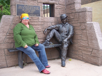
We headed out of Belle Fourche, south on Highway 85 to I-90, picked up 90 going west, and exited to Sundance a short time later. We could see there was rain up ahead, but fortunately we managed to miss it. Sundance is probably best known as the town where the outlaw Harry Longabaugh spent 18 months in jail – and afterwards adopted his nickname, the Sundance Kid. Before that, of course, it was open land at the foot of Sioux Mountain where Sioux Indians roamed and performed their ritual dances.
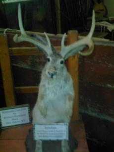
Things were quiet in Sundance on the day we visited, but there was evidence that it had been quite the opposite the day before: a three-by-four-foot patch of “laid rubber,” where obviously a burn-out contest had claimed several tire victims. Our guidebook had suggested a visit to the Crook County Museum (“old West artifacts!”) located in the basement of the courthouse on Cleveland St. Always a sucker for artifacts, we parked the bikes next to the laid rubber and were delighted to see that the first “artifact” inside the museum was a stuffed jackalope. Ah, my kind of place.
 Now I have to say, the folks who put this museum together did a wonderful job – especially given the size of the community and the limited space they had to work with. There were indeed plenty of “old west artifacts,” arranged in little vignettes such as the cowboy’s bunkhouse and “The Sundance Kid was convicted here” courtroom. Signage explained many of the items on display, and the staff members were friendly and helpful. We spent probably an hour exploring the museum, then took photos next to a commemorative statue of Longabaugh. We had thought we might grab lunch at Higbee’s Diner on N. 3rd Street, but upon entering discovered that every single seat was occupied. We decided instead that we would stop in Hulett when we passed through and get something to eat there.
We left Sundance along Highway 14, then picked up Highway 24 north to Devil’s Tower. It really is a different view from this direction, but we did not stop for a second visit at the Tower. Instead we continued east along 24 til we got to Hulett. It was pretty quiet here, too, and our first restaurant choice had actually closed for the day by the time we arrived. Good thing, too, because that forced us to continue on around the corner to grab a sandwich at “R Deli,” which was quite simply outstanding. Steve said he had the best BLT there he’d ever had (piles of thick-cut bacon), and my roast beef-and-Swiss was excellent as well.
After lunch we continued east on Highway 24 – again, it really does look different heading the other direction – which became Highway 34 as soon as we crossed into South Dakota. We rode on through along 34 all the way to I-90, then west a few miles to the Vanocker Canyon exit at Sturgis. Topped off our gas, and set off down the canyon road. 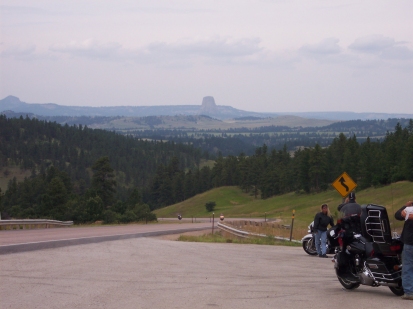
Maybe even moreso than Iron Mountain Road, I love these canyon roads because they are curvey without being distracting in their level of difficulty. The canyon itself is a wandering ribbon of highway surrounded by rocky bluffs that are covered in native spruce and Ponderosa pines. (Have I mentioned yet that this whole region smells like cedar and pine? It’s heavenly.) It was very similar to the way I’d remembered Spearfish Canyon from 2006, but with its own unique features and beauty. One thing I did notice was that by this time, it was getting a bit dark. Not because the sun was going down, but because it was becoming overcast. By the time we reached the end of the canyon road and turned to the west on Nemo Road, I was riding with my sunglasses positioned down at the end of my nose so I could look over the top of them – it was too dark riding with them otherwise. This was an indication that the usual afternoon rain was going to come in as planned (the lightning up ahead was another sign), and if we were unlucky we’d get caught in it.
We zipped along Nemo Road to the west, and where it connected with Highway 385 we stopped for a bathroom break. It was here that I broke one of my cardinal rules of Sturgis-area riding: I had positioned us so that we were going to have to turn left onto the highway to go our desired direction, crossing heavy traffic. To make matters worse, the driveway exiting onto the highway was on an incline. Anyone who rides, or anyone who drives a stick-shift car can tell you that the challenge here is to not stall the vehicle, give it just the proper amount of feathered clutch and throttle, AND avoid being killed by oncoming traffic – two directions’ worth! Now mind you, I *hate* these kinds of challenges. I like having conquered them, but I hate having to do them.
 Fortunately, we caught a break in the traffic and both got out onto the highway at the same time. Heading north, we had a sense that our luck was going to change – it was sprinkling. The problem here, of course, is not only that a wet road is a slick road…it’s also that there’s no way to clean the water off your windshield while you’re riding. So you have to look over the top of the windshield, which means the sprinkles are hitting your glasses. Which you ALSO cannot really clean well while moving. Or which, perhaps, you’ve already put away in your saddlebag at the potty stop because it was too dark to wear them.
In any case, you’re kinda screwed in the rain when it comes to moving forward. We pressed on briefly through the sprinkles, heading north along 385, but finally decided we really needed to pull over. We picked a turn-out that I’m CERTAIN is the same turn-out we’d picked in 2006 for the exact same purpose – putting on our rain gear. We donned our jackets, and took off again, but not too far up the road it started raining hard enough to the point where I just couldn’t see anymore.
Okay, so to recap: it’s raining, it’s slick, I’m getting soaked, and it’s time to pull off again. I realized, once we got stopped, that the turn-out I’d picked was at the highest point on the hill we’d been climbing. (Are they hills? Mountains? I guess compared to the Rockies, they’re hills. At this point in our ride, however, in my mind they were mountains. Impassable, never-ending, biker-eating mountains.) And the lightning was now directly overhead, cutting across the sky seemingly just 100 feet or so off the ground. At this point I happened to look across the road and saw my first deer of the entire trip. She was sitting there, chewing, and staring at us. Mocking us, protected as she was in a grove of trees. It was the last straw. The lightning, the rain, my wet clothes, and that stupid friggin’ deer were just too much, and my lower lip started to quiver. Hey, I may be a biker, but I’m still a girl. I reserve the right to cry at the drop of a hat. Hell, I could always blame it later on monthly hormones.
 But I didn’t. I was stomping around at the turn-out, mad as hell, and happened to look over at Steve. “Hey now, it’s all part of the adventure. We’ll be fine, but we have to get off the top of the hill,” he said. So I cut off the impending tears and just got back on the damn bike, and rode it on down the hill. We could see brighter skies just a mile or so ahead, and knew we’d be out of it soon.
Except we weren’t. Instead of letting up, it continued to rain as we progressed slowly northward along 385. By the time we got to Lead, it was raining again pretty hard and the sky was completely overcast – as if the rain had settled in for a good long time. I had it in my mind that Spearfish Canyon was just on the north side of Lead, but once in Lead itself I realized I was unfamiliar with the roads. After riding through the middle of a neighborhood, I pulled off briefly across from the junior high school to reassess and then pressed on rather blindly. We ended up in Deadwood, with the rain coming down, and I told Steve, “Screw Spearfish, I’m going to skip the canyon and just get home by the route that I know.”
We passed through Deadwood and shot out the other end heading north on Highway 85. By the time we reached I-90 to head west back to Belle Fourche, it stopped raining completely. The last few miles of the trip were run in relative safety. We arrived back at the motel having missed Spearfish Canyon, and completely soaked. Perhaps next time we would be smart enough to put the rain gear on BEFORE it started raining. Perhaps not.
One interesting note, this storm continued eastward and once it hit Sturgis (where we’d been just a couple hours before), it dumped baseball- and golfball-sized hail on everything from folks in cars to folks on bikes and folks camping in tents. As frustrated and near tears as I’d been, I was damn thankful that our share of the storm had merely been the rain.
Sturgis 2009, Day Five: The Heads, the Indian and the Twisties
by Corn Dog on August 15, 2009
in Sturgis 2009
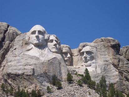
We could hear the traffic heading to Devil’s Tower along highway 34 right outside our motel door from the moment we woke up on Wednesday morning. We commenced with smugly superior hand-wringing a la Snidely Whiplash, knowing we had beat that system and were instead headed to Mount Rushmore and some amazingly challenging roads – Iron Mountain Road and the Needles Highway.
 We’d taken this ride in 2006 and riding those two roads was a real highlight of the trip. Other roads connect the two highways and form the Peter Norbeck Scenic Byway, a route that showcases the beauty of the bluffs, hills and rockfaces of the region. (The route is named for former South Dakota Governor Peter Norbeck, who planned, surveyed and laid it all out back in the early part of the 20th century. Norbeck was also instrumental in launching the carving of Mt. Rushmore and in establishing Custer State Park.)
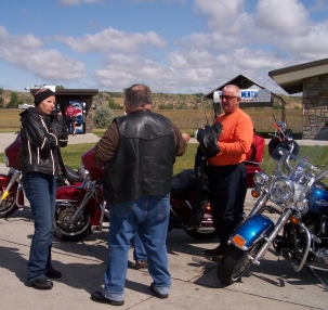
In 2006 we had taken a detour through Custer State Park called the “wildlife loop,” but not having seen much in the way of wildlife I had decided to skip it this year and just connect the two highways with the road that runs along the north end of the park. The group for this ride only included Steve, Garry, Kristin and I – Chuck would soon be returning from his early morning ride, and his plan was to go with Shirley and Nancy down to Deadwood for a day of stimulating the local economy via the many casinos.
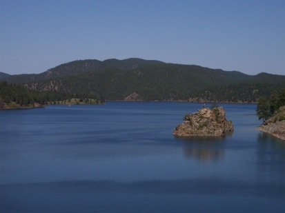 We left Belle Fourche and traveled a few miles south to pick up I-90, traveled east to the Deadwood exit, and shot through Deadwood (thankfully by-passing the main street, which was an impassable clot of traffic and people), coming out the other side on Highway 385 South. A short time later we stopped for a break at Pactola Reservoir, then passed through Hill City, and just past that we picked up Highway 244 East to Mt. Rushmore. These are all very scenic roads in their own right and because so much of the day’s traffic was diverted to Devil’s Tower we were able to enjoy the surroundings more thoroughly than on our last trip.
Sad to say that the “awe” factor of visiting Rushmore wasn’t as strong this time around – it is still a beautiful memorial, but the downside of taking the same vacation you took three years ago is that the novelty of the attractions can wear off. Still, it was a lovely stop. While here, we discussed a change in our itinerary for the day. Garry and Steve were very interested to see the Crazy Horse Monument – a rock carving similar to Rushmore that is still under construction a few miles away after several decades of work, honoring Lakota Sioux Chief Crazy Horse. After consulting our handy-dandy map of the Black Hills, I determined that the most logical way to add this to our itinerary was to eliminate the Needles Highway from the day’s ride. Since it was so similar to Iron Mountain Road, I wasn’t overly disappointed to make this change, and the group was amenable.
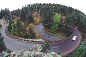 We left Rushmore and topped off our gas in Keystone, then headed south again along U.S. 16A – the Iron Mountain Road. As I noted in my 2006 report on this ride, IMR on the map looks like a thrill-ride of twists, turns, tunnels and switchbacks. And it is that, except you also have the “topography factor” at work – you can be going around a hairpin curve on an incline, and when you come around the curve itself you’re suddenly going downhill, approaching a one-lane tunnel on a blind curve. For me, this road is sheer delight – my bike is among the most nimble in the HD line, and it’s quite simply joy to set your line for a curve, ride it through, then right yourself and immediately set for the next curve. Managing your speed, lean, and counter-steer flawlessly makes you understand what it means to be “one with the machine” – at this point you are not just riding the bike, you are part of it. The ABATE of South Dakota Foundation publishes a map ranking Black Hills Roads according to level of difficulty, and IMR and Needles Highway are two out of only three on the map that are marked as the most difficult. I’m proud to say I’ve ridden both with no problems.
(The photo above, by the way, is from www.byways.org and shows the “pigtail bridges” that lead into the three tunnels along IMR.)
Along the twists and turns of IMR we took a few minutes to stop at an overlook area, and also rode past the folks from MeandMyRide.com, who were snapping photos of individual bikes as they came around one of the curves. (Here’s the page that links to the pictures of the folks in our little group – look for the pink helmet, and see if you can find me!)
16A takes a right turn at the end of IMR, and we soon found ourselves at the entrance to Custer State Park. They wanted to collect another $10 per bike to enter the park, but I chatted with the Ranger who approached us and explained that we only wanted to get across to 385 so we could go visit Crazy Horse. He was a good-humored (and rather good-looking) young man named Mark, and told us to go on through without paying, but instructed us not to stop along the way, use any of the Park facilities, or take the Needles Highway. I gladly led the group across the north end of Custer State Park following his instructions, not sure whether I had actually sweet-talked him or whether they routinely make this exception for those not using the wildlife loop. At any rate, we soon found the Crazy Horse Monument along US 385, and pulled in to explore.
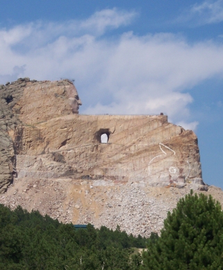 Because so little of the actual monument is finished at this point, the Visitor’s Center offers the most in terms of education and appreciation for the work to be completed. There are numerous actual photographs of chiefs from the various Sioux clans, a scale model of the planned monument, and an extensive exhibit of Sioux historical and cultural artifacts. What you get by visiting this monument (and other similar landmarks in the Black Hills region) is a sense that the romantic stories of the “American West” really should be off-set by a more thorough understanding of just how violent and unjust the taking of this land was. I don’t pretend to be educated on that topic, but suffice to say that a visit to the Crazy Horse monument leaves one impressed, but vaguely uneasy.
The last leg of the day’s trip took us back up 385 to the north, again through Deadwood, and back up to Belle Fourche via I-90 and 85. Had I known what the next day would bring, I would’ve taken this opportunity to lead the group through Spearfish Canyon instead.
Sturgis, 2009: Day Four, Beyond the giant nipple
by Corn Dog on August 14, 2009
in Sturgis 2009
 Everyone goes to Devil’s Tower on Wednesday of Sturgis Week, through Hulett, Wyoming. I understand it’s a tradition – I get that. The problem is, when you have a bike rally of 300,000-500,000 participants, “everyone” is just way too many bikes. So, having honored the tradition of going to Devil’s Tower through Hulett on Wednesday on our last trip, this time we decided to go on Tuesday to see if we could actually have fun.
It was probably the best decision we made the entire trip, because it made a HUGE difference.
First off, the weather was delightful – very cool in the morning when we set off heading west on Highway 34 from Belle Fourche, and bright sunny skies with mild temperatures most of the day. Secondly, there was noticeably less traffic on this day, so we were able to enjoy the scenery a bit more (okay a LOT more) than last time.
I had forgotten how pretty Highway 34 was (Highway 24 once you cross the state line into Wyoming), so it was a pleasant surprise to ride past the Aladdin Tipple (a contraption used in coal mining) and Aladdin Store, through the tiny town of Alva, and then through Hulett – which still had a nice crowd of people and bikes even if they were also a day early.
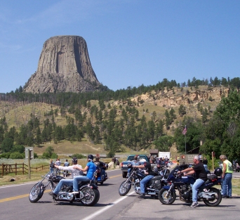
 Once through Hulett the next stop is Devil’s Tower, and the ease with which we pulled in and parked at the Trading Post was another pleasant surprise. We bought snacks and took pictures of the area, and several of us decided to pay the Park fee to travel to the backside of the tower.
A well-groomed and winding road leads from the trading post along a beautiful grassy area with the Tower on the right, offering a more close-up view. Prairie dogs, considered a nuisance in the area, popped up from their holes and then quickly disappeared again, over and over as we passed the grassland on the left side of the road.
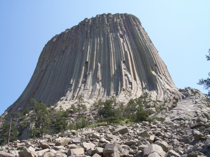
Around several bends and we arrived at the Visitor’s Center, where volunteers took note of how many in our group and maintained an organized parking system to keep us all together. Off the bikes, we walked up a short trail to the base of Devil’s Tower itself – we got as close as the collection of fallen rocks at its base, but to go further we would have had to sign a liability waiver. It had been a steep enough incline just up to that point – none of us were prepared for a serious unplanned climb, so we remained content to take pictures from the small clearing in the wooded area just below the fallen rock debris.
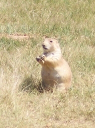 After a short stay, and disappointed that the government’s alien contact station was no longer there (you have seen “Close Encounters of the Third Kind,” right?) we headed back down to the parking lot and departed along the Park road. On our way back to the Trading Post, I made sure to stop and take pictures of the prairie dogs and their grassland habitat.
We left Devil’s Tower a short time later and returned to Hulett, this time turning north onto Highway 112 just outside of town, as an alternate route back to Belle Fourche. Here’s the difference the weather makes: this route cuts through a very isolated area, crosses the Wyoming line into Montana, and ends at a T-intersection with Highway 212, seemingly in the middle of nowhere. In 2006 it was about 105 degrees the day we came through here, and it seemed to take forever to get to the gas station at the 212 junction.
On such an unseasonably cool day as we had this year, though, it did not seem nearly as isolated and did not feel like it took nearly as long to reach the junction. It’s actually only about 30 miles from Hulett, and from the gas station, only about 40 miles on to Belle Fourche. (I had another “suck it up” moment along  those last 40 miles, as again the crosswind was really harsh, but the secret to taking these jaunts in 40-mile stretches is that, by the time I start to feel beat up by the wind, I’m usually more than halfway to the next mark so it’s easy to bear the last several miles knowing I’m almost there.)
We arrived back in Belle Fourche pretty early, and planned our decidedly non-traditional Wednesday ride to Mt. Rushmore, Iron Mountain Road, and Needles Highway – some of the best twisty roads in the region.
Sturgis 2009: Day Three, Mother of all Rallies
by Corn Dog on August 13, 2009
in Sturgis 2009
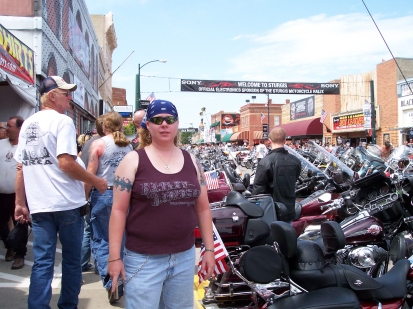 The Sturgis Rally is really just a big ride-in – it began its life as a hill-climb event hosted by a local riding group called the Jackpine Gypsies. How it grew so large is a story for another post, but it has become a sort of Mecca for bikers of every type, from casual weekend riders to the hardcore outlaw gangs. Today it’s not only a hill-climb event but also a people-watching and vendor exhibition that takes up pretty much the entire town for a week.
We took Kristin for her first-ever visit to the Sturgis Rally via Highways 212 and 34, which is a “back way” that goes past Bear Butte – another stunning land formation. We parked in Sturgis a couple blocks from Main and Lazelle Streets, which are the two streets on which the vendors and bikes are concentrated. Vendors are everywhere selling everything from t-shirts to chromey bits to leather apparel and more, so we walked and shopped for most of the day. We ate free grilled sweet corn at the  Progressive Insurance exhibit, saw some wonderfully humorous artwork by one of the vendor artists, and got the usual eye-full of Sturgis fashion do’s and don’ts. (Surprisingly, it IS possible to be too old to wear a bikini top.)
After a day of this, Steve and I were ready to leave the rally itself behind, while the rest of our group made plans to return on Thursday. We rode out of Sturgis through the neighborhood streets onto Junction Avenue, then back to Belle Fourche along I-90 and Highway 34. Dinner was again at the “choke-and-puke,” as the little diner came to be known (it’s actually a very good café – large portions and low prices on very good food), with a planned Tuesday run to Devil’s Tower coming up next.
Sturgis 2009: Day Two, South Dakota Breezes
by Corn Dog on August 12, 2009
in Sturgis 2009
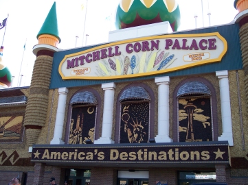 You can’t really stay in Mitchell, South Dakota without visiting that city’s primary attraction, the Corn Palace. The Corn Palace was originally built in the 1800’s by a guy who got tired of people claiming “you can’t grow anything in South Dakota.” He proved them wrong by covering the outside of the building in local crops, and each year since it’s covered in a new design. In doing so, of course, he also “put Mitchell on the map” with this unique and slightly weird tourist trap.
In 2006, we stopped outside the Corn Palace for photos, but didn’t go inside. This year, I ventured in to see what was there and – surprise! – the Corn Palace is actually a concert/performance venue. In the lobby are exhibits showing off past corn designs and detailing the facility’s history.
We left Mitchell at about 10 a.m. and headed west on I-90, taking a butt break at the Chamberlain rest area. I mention this because this facility has a really informative and interesting exhibit about the Lewis & Clark expedition, as well as a wonderful scenic view of Lake Francis Case along the Missouri River. (Chamberlain is also home of the Akta Lakota Museum, dedicated to the history and culture of the Plains Indian tribes.)
As in 2006, gas stops were again in Kennebec and Kadoka – though, again for future reference, Murdo also has complete services and another tourist attraction I’d like to visit, 1880 Town.
 The wind was beating us up pretty good all along here, and by the time we reached Kadoka it was really hot. Quite a difference from the morning, when we’d left Mitchell in our leather jackets.
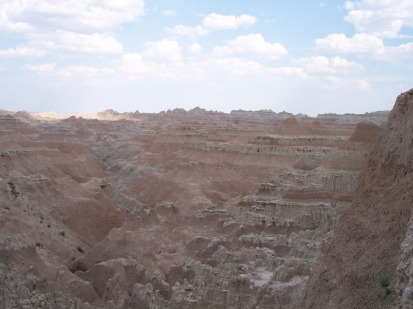
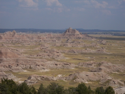
West of Kadoka, we picked up the “Badlands Loop” which is Highway 240 through Badlands National Park. From the Interstate, you do get the sense that the landscape is changing – especially beginning just west of Chamberlain where the grass-covered hills begin to gently roll. Farther west you start to see some bluffs in the distance. But the Badlands loop offers up the full beauty of a very different landscape that lies just south of the Interstate.
It’s hard to believe that this area is just a few miles from the green rolling hills along I-90: barren eroded ledges with striations of the various rock layers clearly visible… giant craters of jagged layered rock, hundreds of yards across… beautiful grassland with these barren formations jutting from the ground… and a sweeping curvaceous highway taking you through it all with a multitude of turn-out points for stopping to marvel at the view and take photographs. South of this is another highway through the Badlands National Grassland – also beautiful, I’m sure, but more prairie-like and without the up-close view of the rock formations according to the helpful attendant at our Chamberlain stop.
 The Badlands loop ended with a straight 8-mile stretch into Wall, SD, and the worst cross-winds of our trip – I felt like my helmet was trying to lift off from my head.
Having started this day at one famous South Dakota tourist trap, we of course had to stop at the other: Wall Drug. In the old days of cross-country travel, Wall Drug was simply a drug store where you could get a free drink of water as a reward for having crossed nearly the entirety of hot, dry South Dakota. Today, it’s a series of shops selling everything from sundries to souvenirs, situated on Main Street in Wall – a tiny town of about 800 permanent residents who welcome millions of tourists all year long.
Although we were all feeling pretty beat up by the time we reached Wall, we still had almost 100 miles to go – time to suck it up and ride. Which we did, on through Rapid City with a butt break at the Tilford rest area, past Sturgis, and up Highway 34 to Belle Fourche.
We arrived at our motel around 7 p.m., had supper at the diner next door, and dropped into bed. We were heading into Sturgis the next day.
Sturgis 2009: Day One, half-way there
by Corn Dog on August 11, 2009
in Sturgis 2009
 I had all good intentions of “live-blogging” the trip to Sturgis this year, thinking it would make for more interesting write-ups AND save me the trouble of doing all the writing at once upon my return. But, I learned a few things out there on the road.
First, just because a place says it has wireless internet service doesn’t mean it’s going to be convenient or reliable.
Second, having access doesn’t necessarily mean I am going to be in any condition to write coherent sentences at the end of the day, let alone string several of them together into an amusing (or at least accurate) story.
So the live-blogging plan was quickly shelved pretty much at the end of Day One, which took us from Des Moines to Mitchell, South Dakota.
We took the same route as we had in 2006: west on I-80/680, north on I-29, then west on I-90 to Mitchell. Stopped for gas at Walnut, gas and lunch at Onawa, t-shirts at Rooster’s HD in Sioux City, the “Road to Sturgis Party” at J&L HD in Sioux Falls, SD, and stayed overnight at the Best Western in Mitchell.
This trip, though, was different because we had several other riders/friends with us – we left Des Moines with Garry, Shirley and Kristin, and met up in Sioux Falls with Shirley’s sister and brother-in-law, Nancy & Chuck. Including Steve and I, we had six bikes and seven people – a manageable group of experienced riders.
 Also different this year was the weather. While our 2006 trip was almost stiflingly hot, only one time this year did we experience real heat. The rest of the week was unseasonably cool with daytime temperatures mostly below 85, night-time temps in the upper 50’s, and skies running the gamut from bright blue and cloudless to partly cloudy or overcast and, a few times, dark and threatening.
One thing that wasn’t different? The wind. The Interstate riding to, from and across South Dakota was ridiculously windy, to the point where I just felt beat up at the end of those days. In fact, the wind was the primary reason for this trip’s nickname, The Suck It Up Tour: when you’re trying to reach a destination that’s 700 miles away, and the bike is your only mode of transportation, well, you just have to “suck it up” and ride.
And suck it up we did, all the way across South Dakota on Day Two.
Sturgis 2009: The Suck It Up Tour is done
by Corn Dog on August 10, 2009
in Sturgis 2009
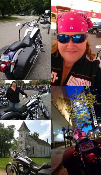
 Wanted to state for the record that we have returned from our 2009 visit to the Sturgis rally – a trip we’ve officially dubbed the “Suck It Up Tour.” Our group included myself and hubby Steve, Kristin, Shirley and hubby Garry, and Shirley’s sister Nancy and hubby Chuck. Full ride reports and commentary coming soon, but here’s the quickie version of our itinerary so you can see how we spent our 9 days and 2,020 miles:
Day 1 – Des Moines to Mitchell, South Dakota.
Day 2 – Visit Corn Palace, ride through the Badlands, Wall Drug, and on to Belle Fourche, SD.
Day 3 – Visit the Sturgis Rally.
Day 4 – Ride to Devil’s Tower, Wyoming.
Day 5 – Ride to Pactola Reservoir, Mt. Rushmore, Iron Mountain Road and Crazy Horse Memorial.
Day 6 – Ride to Sundance, WY, and Vanocker Canyon/Nemo Rd. near Sturgis.
Day 7 – Day off to prep for return trip home.
Day 8 – Belle Fourche, SD to Mitchell.
Day 9 – Mitchell, SD to Des Moines.
More soon!